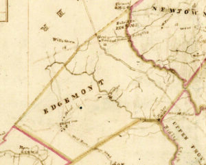
 In 1816, the Pennsylvania legislature authorized mapmaker John Melish to make detailed county maps for Pennsylvania. Melish walked through the township, asked local residents about the local conditions, and drew a fairly detailed map with the tools of the 19th century. What did he find notable enough to include on the Edgmont map?
Two steams ran parallel to each other, north and south. Crum Creek formed the township’s eastern boundary and hosted several mills – the “PSG mill” (paper, saw and gristmill) run by George Entriken, and just over the township line at Willistown, the Isaac Thomas gristmill, built in 1774. Ridley Creek bisected the township, entering from the north near Ockehocking and leaving at the south near Amor Bishop’s mill, later Sycamore Mills in Ridley Creek State Park.
Two main roads ran parallel to the creeks. Providence Road entered the township from the south and made a bee-line to the President’s Tavern (today’s La Locanda) at Mile Post 14 of the West Chester stage road (distance measured from the Schuylkill River bridge near today’s Market Street crossing). The West Chester Turnpike crossed Crum Creek via an existing bridge. The West Town Stage Road also entered from Middletown Township and headed for “Rising Sun” (today’s Gradyville), named for the tavern then operated by William Sill. From there, the road branched, right to Ockehocking (today Delchester Road) and left to Thornbury. There was one east-west road, today’s Gradyville Road, meandering in from Newtown, crossing Ridley Creek via bridge as it does today, into Rising Sun, and then west to Thornbury.
 Public transportation? One stagecoach could take you east to Philadelphia or west to West Chester, while the other headed south to the county seat at Chester, or north to West Town. The only settlement of note was Rising Sun, hosting the tavern, a school and a variety of black dots likely representing other businesses –a general store, a blacksmith and a wheelwright shop. The stagecoach stopped at the tavern, where thirsty travelers and their horses would find refreshment. The only other commercial activity seems to be the President Tavern, opened in 1806, and in 1816 hosted by Abel Green – his name was included on the map.
The Edgmont of 1816 was a farm community of about 625 people. It remained so throughout the 19th century and well into the 20th century, its population never exceeding 1000 until 1950.
For more on the history of Edgmont, visit the Edgmont Historical Society Facebook page at
https://www.facebook.com/groups/1413849356130161.